Severe flooding affects area
Published 1:39 pm Monday, February 19, 2018
- Severe flooding has affected numerous areas of Lawrence County, causing several road closures and restrictions.
Several road closures, restrictions throughout county
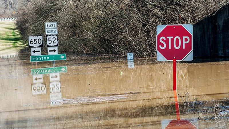
Heavy rain has caused severe flooding along the Ohio River, and numerous areas throughout Lawrence County have seen the rapid rise of water, bringing road closures and restrictions.
In Ironton, the street department put up floodwall #10, which measures 48 feet, at N. Second St. and Hicks Alley, Saturday night into Sunday morning. The city’s second floodwall, floodwall #17, at N. Second St. and Orchard St., is currently in the process of being installed and measures 52 feet.
U.S. 52 is reduced to one lane at the Rock/McPherson Avenue overpass to allow for traffic entering and exiting the highway where the floodgates have been raised. Due to the Ironton floodwalls, closures are in place on N. Second Street in downtown Ironton.
“We also have 10 pump stations going in full flood operation service,” Mike Pemberton, Ironton street superintendent, said. “According to the National Weather Service, the river is supposed to crest here tomorrow.”
Other road closures and restrictions by the Ohio Department of Transportation or the Lawrence County Engineer’s Office due to flooding and high water throughout Lawrence County include:
• State Route 650 is closed between the 7-mile marker at County Road 43 (Kelly’s Mill Road) and the 9.28-mile marker at State Route 522.
• State Route 141 is restricted between the 19 and 20-mile markers between Township Road 110 (Zalmon Road) and County Road 4 (Etna-Waterloo Road).
• State Route 93 is restricted at the 10-mile marker between Township Road 150 (Lawrence Hill Road) and State Route 522.
• State Route 243 is closed between State Route 378 and County Road 36 (McKinney Creek Road), as well as between County Road 68 (Shafer Town Road) and County Road 2 (Greasy Ridge Road).
• County Road 181 at the 0.60 and 1.60-mile markers is closed.
• County Road 22 at the 0.70-mile marker is closed.
• County Road 42 at the 1.35-mile marker is closed.
• County Road 402 at the 1.10-mile marker is closed.
• County Road 123 at the 1.40-mile marker is closed.
• County Road 123A at the 0.05-mile marker is closed.
• County Road 1 at the 9.90-mile marker is closed.
• County Road 73 at the 0.25-mile marker is closed.
The Ohio Department of Transportation reminds motorists that crossing any closed route is strictly prohibited. Motorists should also avoid traveling on roadways where standing water may be present, although the roadway may remain open.
The Lawrence County Engineer’s Office is also continuing to watch several other roadways.
More News


-
Polls
 Loading ...
-
-