Three more counties move to highest alert level
Published 6:52 pm Wednesday, November 25, 2020
- Ohio Department of Health
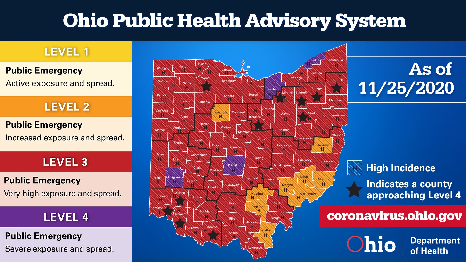
COLUMBUS — Four counties in Ohio are now listed at Purple Level Four in the latest update of the state’s COVID-19 alert map.
Montgomery, Lake, and Lorain counties moved to the highest risk level on the four-tier system, while Franklin County remained at the designation for the second week.
The newest Level Four counties are among the most populated in the state. Montgomery County is the fifth-most populous county and is where Dayton is located. Lake and Lorain counties are part of the greater Cleveland metro area. While Franklin is the Columbus area.
In addition, 11 counties at Red Level Three have moved to the watch list in the system.
Lawrence County remained at Red Level Three for the eighth week in a row. Neighboring Scioto and Jackson counties were also at that level, while Gallia County remained at Orange Level Two, one of only nine counties still at that designation.
This week saw 75 counties were at Red Level Three, an increase of three from last week.
No counties were at the lowest alert, Yellow Level One.
The system, compiled by the Ohio Department of Health, is determined by seven data indicators — New cases per capita, sustained increase in new cases, proportion of cases not congregate cases, sustained increase in emergency room visits, sustained increase in outpatient visits and sustained increase in new COVID-19 hospital admissions — that identify the risk level for each county and a corresponding color code to represent that risk level.
DeWine issued this week’s map a day early, as the typical Thursday release fell on Thanksgiving Day.
He urged Ohioans to not hold large celebrations, due to the pandemic.
“Be safe,” he said. “Celebrate small.
More News


SportsPlus
How to Watch MLB Baseball on Friday, July 26: TV Channel, Live Streaming, Start Times
In a Friday MLB schedule that features a lot of exciting matchups, the Cleveland Guardians versus the Philadelphia…
How to Watch the Reds vs. Rays Game: Streaming & TV Channel Info for July 26
Elly De La Cruz and the Cincinnati Reds hit the field on Friday at Tropicana Field against Shane…
Reds vs. Rays Series Preview: TV Channel, Live Streams, Starting Pitchers and Game Info – July 26-28
A three-game series between the Tampa Bay Rays and the Cincinnati Reds at Tropicana Field is set to…
Reds vs. Rays: Betting Preview for July 26
In the series opener on Friday, July 26, Shane Baz will take the mound for the Tampa Bay…
Cleveland Browns vs. New Orleans Saints Week 11 Tickets Available – Sunday, November 17 at Caesars Superdome
On Sunday, November 17, 2024, the New Orleans Saints (0-0) and the Cleveland Browns (0-0) play at Caesars…
-
Polls
 Loading ...
-
-